NSO-GfÖ 2026: pre-announcement of treeline session
Abstract submission (opening in spring 2026): until April 17, 2026
Welcome to Alpine Treelines Online
Please use the buttons above and the navigation bar to access the treeline map and other treeline-relevant information.
This website is still under development.
To be kept up-to-date about important developments about this website, please sign up for the newsletter.
Abstract submission (opening in spring 2026): until April 17, 2026
European Geoscience Union: 3-8 May 2026, Vienna, Austria
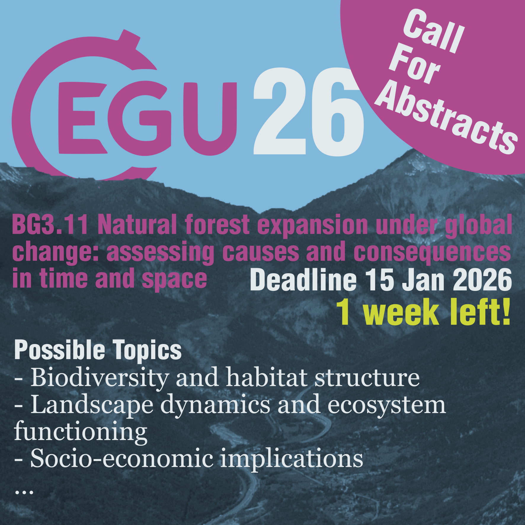
Session BG3.11 – Natural forest expansion under global change: assessing causes and consequences
in time and space, convened by Matteo Garbarino, Uta Schirpke, Nicolò Anselmetto, Arthur Bayle, and Aitor Améztegui
Natural forest expansion is occurring across many regions as a result of intertwined climatic and
land-use changes. This process is shaped by multiple drivers acting across spatial and temporal scales.
While broad-scale shifts in vegetation are often linked to global warming, the abandonment of agricultural
activities remains a key socio-economic trigger of local secondary successions. The interaction between
these climatic and human-related dynamics makes the analysis of forest expansion inherently complex and
multidisciplinary.
This session welcomes contributions that use spatially explicit and diachronic approaches - such as optical,
SAR or LiDAR remote sensing, historical cartography and aerial imagery, permanent plots, ecological modelling,
and socioeconomic analysis - to understand where, why, and with what consequences forests expand. Although
many local case studies exist, most research remains limited in spatial extent or temporal depth. Historical
datasets - such as cadastral maps, vegetation surveys, planning maps, and aerial photographs - have proven
valuable worldwide but still require harmonization and standardization.
We particularly encourage studies that explore:
* Landscape dynamics and ecosystem functioning
* Socio-economic implications for livelihoods, cultural landscapes, and local economies
Our goal is to bring together experts across disciplines, regions, and biomes to
foster integration and comparison at broader scales. Looking ahead, we also plan to develop a perspective
paper emerging from this session, building on the insights and contributions shared by participants.
"Creating and synthesizing knowledge about alpine treeline ecotones in changing mountains"
By: Maaike Bader, Jan 10, 2026
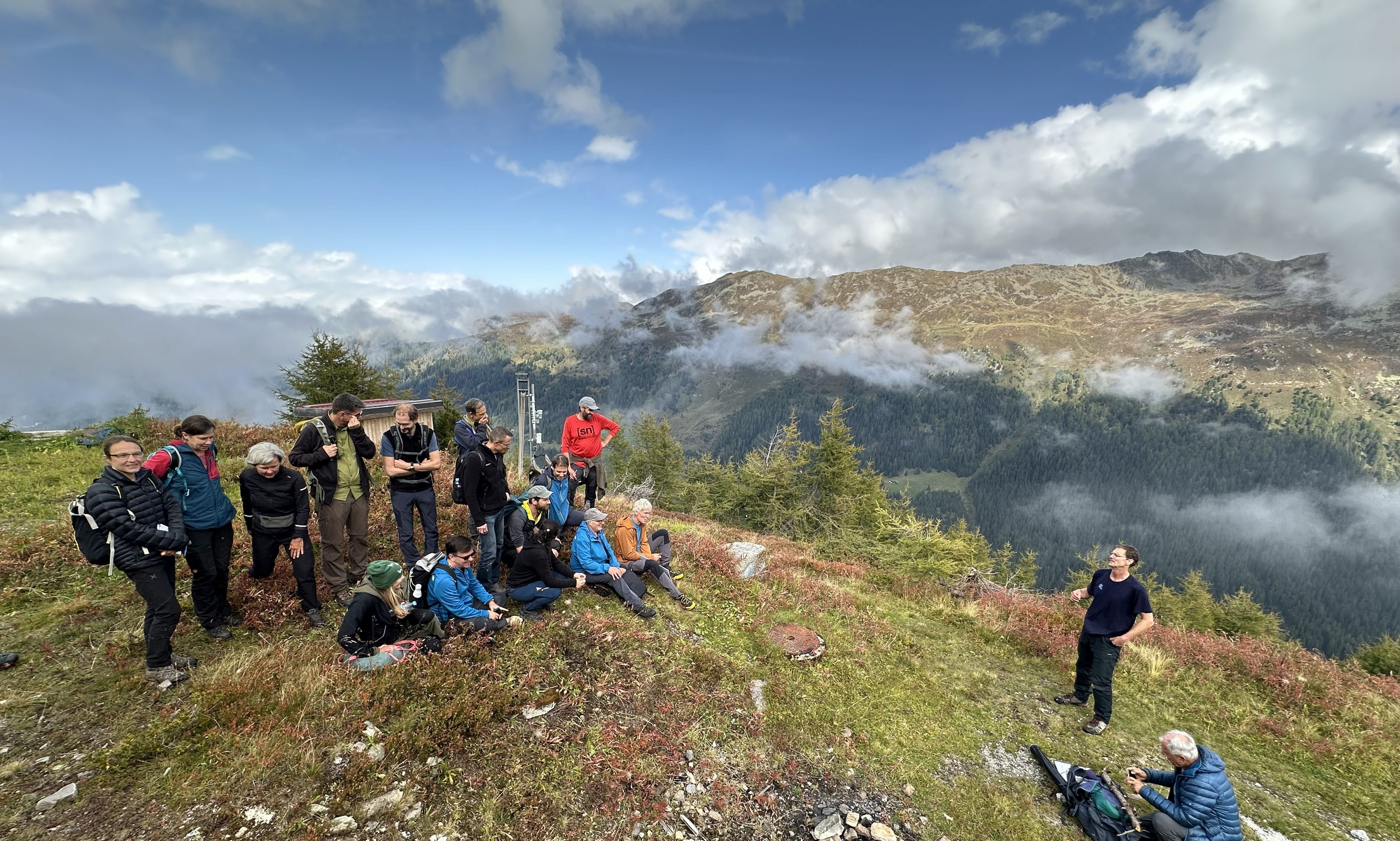
Preparing for a group picture the top of the WSL-SLF Stillberg treeline experiment, scientific excursion in the context of the experiment's 50th anniversary. (Photo: Maaike Bader)
In September 2025, several treeline-relevant sessions at the International Mountain Conference (IMC)
and a field trip to the famous
Stillberg treeline experiment brought together an international group of
treeline researchers in Innsbruck and Davos.
The Stillberg experiment celebrated its 50st anniversary in 2025, which was celebrated with a scientific excursion and a
public event at the site. It was very inspiring to get to know this famous experiment and to meet many of the people behind it,
and to discuss treeline research directly in the field. Interestingly, due to climate warming, this experiment is currently no
longer located at treeline, the thermal limits to tree growth having shifted uphill beyond the highest trees in the experiment.
This poses an important question: how to study climatic limitations to tree growth at treeline in the absence of trees?
Discussing the lessons learned in 50 years Stillberg experiment, there was a strong agreement about the importance of
long-term and large-scale
experiments such as this one for capturing slow responses, spatial variation, rare events, and changes in the importance of
drivers through time and with (tree) life stages, but also as a platform for developing scientific cooperation and for teaching.
The excursion in Davos preceded the IMC conference further east in the Alps, in Innsbruck, so that travel could be easily
combined to attend both events.
At the IMC, organised in Innsbruck for the third time, the atmosphere was open and friendly as always and a highly international
audience enjoyed a wide variety of mountain-related sessions and special events, spanning topics from pasturalism to mountaineering,
architecture to glaciers, and sustainable development to ecology.
Several treeline(-related) sessions took place and were very well attended, with a varied and high-quality program of
11 oral presentations, 9 flash talks introducing the posters of the poster session, and synthesis discussions.
Many of the presentations focused on the European Alps,
geographic coverage within the sessions thus not fully representing the available treeline research, let alone
the variety of treeline ecotones found globally.
Several spatial methods were presented (e.g. using machine learning and/or remote sensing)
, showing how these methods have developed since the previous IMC in 2022. All together, the contributions showed how we are increasingly
able to detect patterns and dynamics in treeline ecotones, while also getting closer to understanding the processes that lead to them,
even if many basic questions (e.g. What comprises a safe site for tree seedling establishment at treeline? How does low temperature
prevent growth into tree stature?) still await a complete answer.
We are looking forward to meeting again and discussing new development in treeline research at IMC 2028, at the latest!
Maaike, on behalf of the session conveners: Klaus Katzensteiner, Johanna Toivonen, Lirey Ramírez, Peter Bebi, and Nishtha Prakash.
You can access the abstracts here:
Focus session "Creating knowledge about alpine treeline ecotones in changing mountains"
Workshop "Synthesizing knowledge about alpine treeline ecotones in changing mountains"
Synthesis workshop, led by Christan Körner "Mountain forests under change – a synthesis"
Field trip to the Stillberg treeline experiment.
Announcement and
short report and pictures of the public anniversary day at the Stillberg treeline experiment.
.